ESRI‘s Support Services recently posted a document that outlines things to check if you are experiencing performance (speed) issues with ArcGIS. It has some ideas that are good practice for general troubleshooting, as well as several suggestions specific to ArcGIS. Check it out.
ArcGIS 10.1 and Metadata
Metadata is ‘data about data’. Metadata for GIS data documents the particulars of a spatial layer: who created it and when, what the layer represents and its purpose, its spatial (and perhaps temporal) resolution, the coordinate system / map projection and datum used by the layer, and a number of other useful bits of information.
Creating metadata is an often overlooked step in GIS processing. Having been on the receiving end of undocumented data, I can state it is an extremely important part of any project you may undertake. There are several reasons to document your layers:
1) If you share your data with others, metadata will make it easier for them to understand the structure and contents of the files. Perhaps more importantly, the metadata should contain the projection used by the data. Receiving layers missing coordinate system information is less of a problem than it used to be, but many older shapefiles lacked a .prj file, requiring a time-consuming (and sometimes fruitless) ‘guess the projection’ process.
2) If enough time passes between when you create and use a layer, metadata may help you recall how the data were produced (processing steps are part of a metadata record).
3) Any grant-funded contract work using funds provided by the Federal Government requires complete, FGDC-compliant metadata as one of the deliverables. If you don’t deliver the metadata, you won’t get paid…
“FGDC-compliant” brings up another topic: metadata standards. There are several different standards, but the FGDC and ISO 19115 are two of the more common ones. Neither standard is particularly easy to read (though are recommended for bedtime reading if you are an insomniac). This graphical guide is easier to understand, but doesn’t help with the creation of compliant metadata.
Fortunately, tools are available to assist in the process. The FGDC maintains a list of software, and ArcGIS has built-in metadata creation and editing tools.
See this brief tutorial for an introduction to creating FGDC-compliant metadata in ArcGIS 10.1.
USGS web map services
The USGS makes a number of their map products available as a WMS Web Map service. These layers are available to use as a backdrop in GIS software, such as ArcGIS or the free, open-source, QGIS.
See http://viewer.nationalmap.gov/example/services.html for a list of the services. Use the Link found under the WMS column in your GIS software of choice.
ArcGIS ModelBuilder tutorial
I have written a short ModelBuilder tutorial that shown how to use an iterator to automate a repetitive process – converting a number of polygon feature classes to rasters in a geodatabase.
If you are interested in learning more about what can be done with the ModelBuilder, explore the ArcGIS Help files (search for ModelBuilder) and work through the two tutorials, or request a code to take the ModelBuilder course from the Virtual Campus.
Introduction to GIS course – first module
I am working on developing a series of self-paced GIS training modules. This first effort is designed for users who have never used ArcGIS before, and is a very simple introduction to using ArcMap.
The data are available to download here.
There is also a link to the data download in the exercise.
More updates and material to follow… You will need access to ArcMap 10.1 and have an Internet connection to complete this module.
An interesting discussion on how software bugs are identified
A user forum thread at ESRI about crashing issues with ArcMap 10.1 SP1 sheds some light on how bugs are identified. Reply # 55 lists the answer.
Apparently ArcMap 10.1 has some issues with stability when the Georeferencing toolbar is open and a large number of rasters are present in a map document. A fix is planned for ArcGIS 10.2 (coming this summer, perhaps July of 2013?) but some workarounds are listed in the discussion.
ArcGIS for Desktop – “Tool not licensed” error
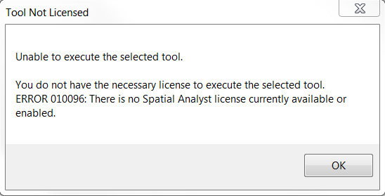
If you receive a ‘tool not licensed’ error when trying to use an ArcToolbox tool from an extension (Spatial Analyst, 3D Analyst, or others) then it’s likely you have not enabled the extension before trying to use it. If the extension has a toolbar, making it visible is not the same as enabling the extension. 
Note that the error message states no… “license currently available or enabled“. The default install of ArcGIS includes all extensions, so it’s likely not enabled if you’re seeing this message.
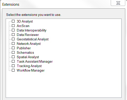
To remedy this, open the Customize menu and choose Extensions…

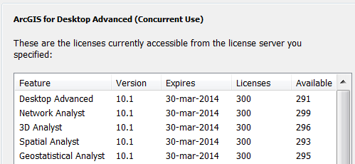
Check the box for any extension you wish to use, and click Close. Try re-running the tool and it should work. To verify if a license is available, open the ArcGIS Administrator and select the Availability panel. Extension licenses will be listed below ArcGIS…
How to update an ArcGIS student edition license
If you are running your own copy of ArcGIS – the Student Edition – the license is valid for one year. It is possible to renew your student license without re-installing ArcGIS or obtaining another install DVD. You will first need to get a new registration code. These are available by sending an email to it-help or to mdhyslop at mtu.edu
Detailed instructions for activating your license are available as a PDF: How to update an ArcGIS Student Edition license.
Please email mdhyslop with questions or comments.
Free ebook – learn statistics with R
http://health.adelaide.edu.au/psychology/ccs/teaching/lsr/
A link to the ebook in pdf format, an order form for a hard copy, code used in the examples, and more can be found at the page above.
ArcGIS Spatial Analyst Supplemental Tools
ESRI has released a set of custom tools for the Spatial Analyst extension. Read the announcement or download them directly.
New tools include Create Dendrogram, Draw Signatures, Filled Contours, Maximum Elevation Upstream, and Viewshed Along Path tools. ArcGIS 10.1 SP1 is recommended.
