Introduction to GIS course – first module

I am working on developing a series of self-paced GIS training modules. This first effort is designed for users who have never used ArcGIS before, and is a very simple introduction to using ArcMap.

The data are available to download here.

There is also a link to the data download in the exercise.

More updates and material to follow… You will need access to ArcMap 10.1 and have an Internet connection to complete this module.

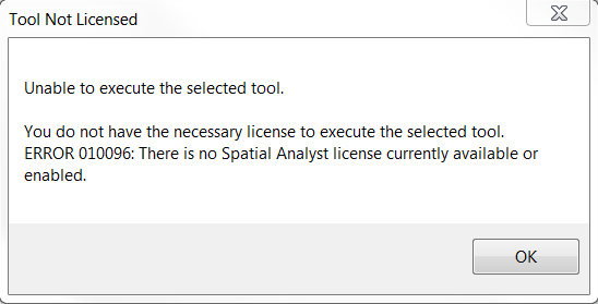
ArcGIS for Desktop – “Tool not licensed” error

If you receive a ‘tool not licensed’ error when trying to use an ArcToolbox tool from an extension (Spatial Analyst, 3D Analyst, or others) then it’s likely you have not enabled the extension before trying to use it. If the extension has a toolbar, making it visible is not the same as enabling the extension.

Note that the error message states no… “license currently available or enabled“. The default install of ArcGIS includes all extensions, so it’s likely not enabled if you’re seeing this message.

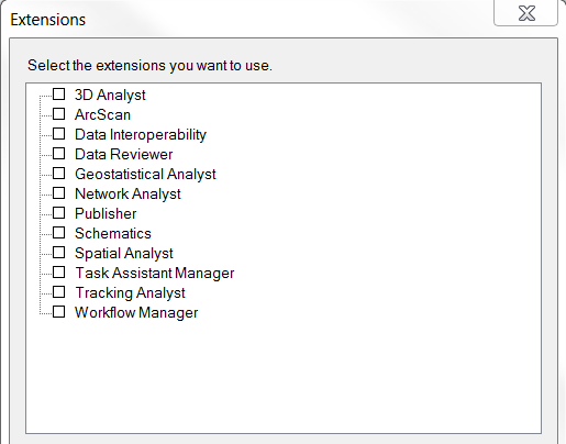
To remedy this, open the Customize menu and choose Extensions…

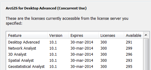
Check the box for any extension you wish to use, and click Close. Try re-running the tool and it should work. To verify if a license is available, open the ArcGIS Administrator and select the Availability panel. Extension licenses will be listed below ArcGIS…

How to update an ArcGIS student edition license

If you are running your own copy of ArcGIS – the Student Edition – the license is valid for one year. It is possible to renew your student license without re-installing ArcGIS or obtaining another install DVD. You will first need to get a new registration code. These are available by sending an email to it-help or to mdhyslop at mtu.edu

Detailed instructions for activating your license are available as a PDF: How to update an ArcGIS Student Edition license.

Please email mdhyslop with questions or comments.

Important ArcGIS 10.1 updates

Greetings,

ESRI released Service Pack 1 for ArcGIS 10.1 in late October. This service pack fixes several hundred bugs, and includes other interesting functionality (mainly the release of 64-bit background geoprocessing, allowing for the use of > 4GB of RAM!).

To find current patches and service packs for 10.1, go to http://support.esri.com/ and choose the link Patches and Service Packs under Downloads. Choose ArcGIS for Desktop from the list. Under the Browse Filter, uncheck Version 10 and click Go. Only updates for ArcGIS 10.1 will be listed.

Important patches to apply:

ArcGIS 10.1 Service Pack 1 for (Desktop, Engine, Server)

ArcGIS 10.1 SP1 for Desktop Background Geoprocessing (64-bit) (found under the Product section ArcGIS 10.1 SP1 for Desktop. This product must be installed AFTER SP 1 is installed)

ArcGIS 10.1 SP1 (Desktop, Engine, Server) Mosaic Dataset/Image services reprojection Patch (install after Service Pack 1)

Please note if you have other software installed (ArcGIS for Server or the optional software add-ons Data Reviewer or Workflow Manager) there are separate updaters for these products.

If you are unsure what you have installed, search for PatchFinder for Windows on the SP 1 download page. This software (a tiny ~700 kb download) will report what ESRI products have been installed on your computer.

ArcGIS application errors – some troubleshooting tips

Twice today I’ve seen problems with ArcGIS 10 (and 10.1) failing to launch. In one instance, no specific application error was given – ArcMap just failed to start with a ‘serious error’ dialog, and in the other, some direction was provided by ArcMap in the form of an error message.

In both cases, the user had a corrupt default user geodatabase. The location of the default geodatabase may be given in the error message. If not, it should be located in <user profile>\My Documents\ArcGIS. If you are working on a lab machine, the location will be h:\ArcGIS\  The file is named Default.gdb, and if ArcMap has had trouble loading more than once, you may have multiple copies named Default.gdb, Default.gdb1, Default.gdb2…

The ESRI knowledge base article 38523 suggests several fixes, the most important of which seems to be deleting any Default.gdb files in the users profile directory. I found that using Windows worked properly, as ArcCatalog seems unable to remove the offending files. One machine I worked on today had more than 150 default.gdb files (all of which were corrupt and preventing ArcMap from launching).

Tutorial – formatting tabular data for joining to ArcGIS features

Here is a short tutorial that outlines the steps for formatting spreadsheet (tabular) data in preparation for joining it to features (points, lines, or polygons).

If you aren’t familiar with joins, they allow you to attach attribute data that is separate from (external to) your features. In order for joins to work, a common field that contains a unique identifier is needed in both the features and the external data. A join will match records in the external data table to features in the GIS layer based on the values in the unique ID field.

An example of features and data that have this relationship is Census tracts, which change infrequently (features). To the tracts you can join any number of metrics collected or calculated by the Census bureau: residents tabulated by race, income, education; housing stock and attributes (tabular data).

This is a very generic and basic tutorial. Please email with questions or comments.