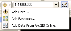
A wealth of spatial data, suitable for many different applications at various scales, is available on the internet. If you are using ArcGIS 10 or ArcGIS Pro, a good place to start is ArcGIS online: 
If you click on the triangle to the right of the Add Data button (the yellow diamond with a black rectangle on top), you are presented with a drop-down menu. Here you may select local data, a basemap from ESRI, or other data layers available on ArcGIS Online. The Add Data… option lets you select files from a local drive or network share.
We hope to offer links to data layers for the region in the near future, but several good places to acquire your own GIS layers include:
1) Michigan Open Geo Data Portal, from the Department of Management, Technology, and Budget.
The Center for Shared Solutions is the official home of GIS data for Michigan. At the Open Geographic Data Portal you can find layers organized by various categories.
2) The Geospatial Data Gateway, provided by the NRCS, FSA, and RD.
The Geospatial Data Gateway (GDG) has data for more than just Michigan. You can select data by state, county, bounding rectangle (latitude and longitude coordinates that describe a study area’s extent), or by using an interactive map to identify a study area, anywhere in the 50 US states or other US territories.
The GDG has the most recent nationwide aerial imagery available, as well as base geography, watershed data, topographic maps, digital elevation models, land cover data, and climate information.
You will need to provide an email address to use the GDG, as layers are ‘custom packaged’ for each order. The wait time for downloads depends on the amount of data you choose to download, as well as the number of other users on the system.
3) The National Map Viewer, from the USGS National Map
The National Map houses the most up-to-date geospatial data from the USGS. It has an interface similar to the GDG’s, with a smaller set of layers available. The National Map is where all topographic map updates will are now published.
4) Digital Elevation Model (DEM) data from the USGS
DEM files, previously available from seamless.usgs.gov, have been moved to the National Map
You may also find data you need at NOAA’s Digital Coast, which houses LIDAR-derived elevation data for (select) coastal counties in the US.
5) A good starting point for satellite imagery for Michigan is MichiganView. This site contains user-contributed images for the region, and is managed by staff at the Michigan Tech Research Institute (MTRI).
6) Some 2020 Census data can be accessed from ESRI. See this blog post for details.
7) Historical (census) data layers may be found at the National Historical GIS. If it’s historical topographic maps you need, see the USGS Historical Topographic Map Explorer, where you can view or download scanned topo maps. Some of these are also available from topoView.
8) Natural Earth provides public domain base maps at various scales (1:10M, 1:50M, 1:110M). Both raster and vector data are available.
9) Mappingsupport.com maintains a list of Public GIS Servers, which is vetted weekly for dead links. For ease of use, CartoLab has made this into a live, clickable list separated by resource type (State, Federal, Other). It is also updated weekly.
page last updated 22 March 2023
