Coastal Vignettes are graphic representations of where land and water meet. Vignettes are symbolized so the land appears to gradually fade into the water, representing shallow areas near shore transitioning into deepening water.
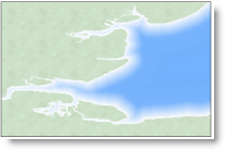
image source: esri
Not wishing to ‘reinvent the wheel’, here are some postings about the creation of coastal vignettes in ArcGIS from the fine cartographers at Esri:
1) Symbolizing Shorelines 2) Ask a cartographer: coastal vignettes 3) FAQ: What are coastal vignettes and how can I create them? 4) Vector and Raster Methods for Creating Coastal Vignettes (ESRI white paper linked from #3).
These were written for older versions of ArcGIS but are still current…