DNRGPS, the new replacement for DNRGarmin, does not handle the Michigan Georef projection properly. If you load an existing shapefile in Michigan Georef coordinates into DNRGPS, the latitude and longitude values are changed to the wrong part of the Earth (About 25 degrees of latitude is added and longitude is changed from ~ -88 to 175 degrees: a change of almost 265 degrees). Similarly, if data is transferred from your GPS to DNRGPS and the Michigan GeoRef projection is then applied, the latitude and longitude values stay correct, but the projected coordinates (used by ArcGIS or other GIS software) are changed so the data are on the wrong side of the Earth.
To avoid problems with your data ending up in the wrong hemisphere, do the following:
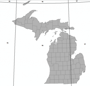
1) If transferring data from your GPS to GIS software, use either unprojected (“no projection” in DNRGPS, which = WGS84 lat/lon) coordinates or the appropriate UTM zone for your part of Michigan (zone 15N in the extreme western UP, zone 16N for most of the UP and the western 2/3 of the LP , or zone 17N in the extreme eastern UP and the eastern 1/3 of the LP). See figure 1 for UTM zones in Michigan.
Figure 1 – UTM zones in Michigan (click for a larger version)
If you need your spatial data to be in Michigan GeoRef coordinates, use the
Project tool in ArcGIS (or the reproject function in your GIS software if you are using another package) to convert your data to Michigan GeoRef coordinates.
2) If you are transferring data in GIS format (shapefile or geodatabase) to your GPS and it is in Michigan GeoRef coordinates, you should first re
project it to either Geographic coordinates or to the appropriate UTM zone.
I have filed a bug report with the developers of DNRGPS, but they have more than a hundred other issues to fix so it may be a while before this is resolved. Fortunately, this is a non-fatal error and can be avoided with some planning.

