Keeping ArcGIS up to date

All software is released with some bugs. Software vendors will periodically provide updates, patches, or service packs to fix issues identified with their software, and Esri is no exception. Discovering what fixes are available, as well as finding the correct updaters on their web site, can be a bit tricky. Below you will find some tips to help a) navigate their support site, and b) decide if you need to install the updates you find.

First, visit support.esri.com. This page has links to esri’s knowledge base and support forums, as well as their downloads. Look for “Patches and Service Packs” at the top of the Downloads list.

The list that appears may be somewhat is overwhelming, as it includes more than 80 products–some legacy, and some that have been renamed over time. The trick is to find the correct product in the list and drill down from there. With a product list whose names have transmogrified in recent years, this is no mean feat.

The esri software that most of us use is ArcGIS, named in the resulting list as as ArcGIS for Desktop. (Please note that if you have any extensions installed, they may be listed separately. You should occasionally check for updates to extensions you use often).

Once in the list of Patches and Service Packs for ArcGIS for Desktop, a browse filter is available on the right side of the page. 
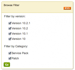
In the browse filter you may deselect the versions of ArcGIS that you don’t use. Clicking the Go button will shorten the list of available updates to include only those for your installed version. The installers will be presented from newest to oldest. It’s still a long list, but is less cluttered and pertinent to your ‘flavor’ of ArcGIS.

Some tips for parsing this list:

• reading the summary for the update will help you decide if you should install it (these are provided on the list page). For example, if you never work with parcel data or imagery in format X, you probably don’t need to download and install patches to fix issues with those data types.

• If you identify patches you think you need to download and install, read the description page for more information. The top of each description page will contain the summary shown in the list (described above) plus hyperlinks to more extensive information, including a detailed description of the patch, what it fixes, who should install it, what it installs, where to download the patch, and how to determine what updates you have already installed.
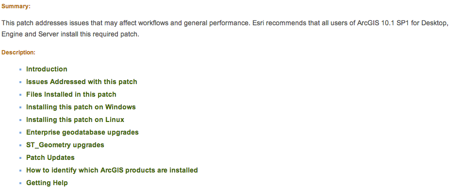
• you probably should install any service packs or ‘quality improvement’ updates. The web page that describes the release will contain a link to ‘issues addressed’ by the software patch. SP1 for ArcGIS 10.1 purportedly fixed over 500 bugs, and the recent QIP release for 10.1 lists over 250 fixes. Wow.

• a service pack will contain all prior patches and updates, so anything older than the service pack doesn’t need to be installed first.

If you have identified updates you need, are a Michigan Tech employee or student, and don’t have administrative access on your office computer, send an email to it-help to request that the patch be installed. Please be specific, with a link to the installer, as well as your computer hostname.

If you have any questions, please contact me directly.

ESRI releases new toolbox

ESRI has released an update to the Spatial Analyst Supplemental Toolbox, bringing the version to 1.3. It adds new tools for zonal statistics and tabulate areas functions, and new options for watershed analysis (he determination of maximum upstream elevation).

An overview and details are available at the ArcGIS Resources blog. A direct download link to the toolbox is http://esriurl.com/SpatialAnalystSupplementalTools  and a complete discussion of the tools in the toolbox is at Introducing the Spatial Analyst Supplemental tools

Please note that ArcGIS 10.1 SP1 or later is recommended.


Important ArcGIS 10.1 updates

Greetings,

ESRI released Service Pack 1 for ArcGIS 10.1 in late October. This service pack fixes several hundred bugs, and includes other interesting functionality (mainly the release of 64-bit background geoprocessing, allowing for the use of > 4GB of RAM!).

To find current patches and service packs for 10.1, go to http://support.esri.com/ and choose the link Patches and Service Packs under Downloads. Choose ArcGIS for Desktop from the list. Under the Browse Filter, uncheck Version 10 and click Go. Only updates for ArcGIS 10.1 will be listed.

Important patches to apply:

ArcGIS 10.1 Service Pack 1 for (Desktop, Engine, Server)

ArcGIS 10.1 SP1 for Desktop Background Geoprocessing (64-bit) (found under the Product section ArcGIS 10.1 SP1 for Desktop. This product must be installed AFTER SP 1 is installed)

ArcGIS 10.1 SP1 (Desktop, Engine, Server) Mosaic Dataset/Image services reprojection Patch (install after Service Pack 1)

Please note if you have other software installed (ArcGIS for Server or the optional software add-ons Data Reviewer or Workflow Manager) there are separate updaters for these products.

If you are unsure what you have installed, search for PatchFinder for Windows on the SP 1 download page. This software (a tiny ~700 kb download) will report what ESRI products have been installed on your computer.

ArcGIS tips document

ESRI has created a nine page ArcGIS Desktop Tips and Shortcuts document. It lists keyboard and mouse shortcuts for many common operations, and identifies which work for versions 9 and 10 of ArcGIS (ArcMap and ArcCatalog). A shorter list is available in the ArcGIS 10 application help files. Tap F1 when ArcMap is running and search for keyboard shortcuts.

You can also use the Help files for ArcGIS 10 in the ArcGIS Resource Center. Search for keyboard shortcuts. Help for other versions of ArcMap (or other ESRI applications) can be found by going to the ArcGIS Resource Center and clicking Help. Expand the list for the application you are interested in (click the +) for help files from the older versions.

Tip: the help files from the Resource Center are the most up-to-date for all ESRI software. Sometimes updated documentation is not included with service packs and patches, but these files are kept current.

ESRI Community Analyst available (soon)

Found in a recent press release from ESRI:

Easy-to-Use Tools Help You Understand Local Issues

Students in colleges, universities, and K–12 schools throughout the United States now have access to Community Analyst through the Esri Educational Site License program at no additional cost.

Community Analyst includes demographic, health, economic, education, and business data for the entire United States, allowing students to study individual neighborhoods within their own communities or compare their communities with others. Because Community Analyst is completely hosted in the cloud by Esri, it eliminates the need for software installation and data management and ensures that students always have access to the latest features and data updates.

Existing educational site license holders should contact the Esri Site License administrator at their institutions for instructions on accessing Community Analyst.


Please note that licensing details are not yet available. Please stay tuned for more information. Community Analyst requires ArcGIS 10.