Generating a regular sampling grid in ArcGIS – an ArcToolbox tool

I have taken a workflow I developed a few years back and converted it to an ArcToolbox Tool (and ModelBuilder model). This tool should work for any license level of ArcGIS (Basic, Standard, Advanced). I developed the tool using ArcGIS 10.2.2, but saved versions for ArcGIS 9.3, 10.0 and 10.1 and later.

The tool has documentation (help) embedded, as well as metadata (item description) text. Be sure to set your Current and Scratch Workspace Environment settings under Geoprocessing > Environments… before trying to use the tool.

Here are links to download various versions of the tool These are shared from Google Drive, so look for the download link near the top of your browser window after clicking on one of the links below.

ArcGIS 9.3 Version
ArcGIS 10.0 Version
10.1 and later Version

Feedback (positive or constructive criticism) on this tool will be appreciated.

Using MapTips in ArcGIS

It is often useful in a map to enable “MapTips” for layers in an ArcMap document. When map tips are on, hovering the cursor over a feature on the map will display the contents of a field from the attribute table in a pop-up window. This eliminates the user’s need to use the Identify tool on a layer.

To turn on map tips, open properties for the layer and choose the Display tab. In the Display Expression box, select the field you would like shown in the pop-up and check “Show map tips using the display expression“.

However, you may find this option unavailable (“grayed out”) when trying to enable map tips.

This is usually caused by the layer not having a spatial index available (see this post from ESRI for more information). The solution is to build a spatial index. This may be accomplished two ways:

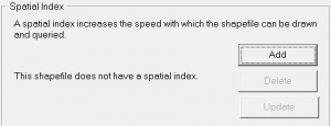
1) in ArcCatalog, navigate to the layer, select it, and open Properties. Choose the Indexes tab and click Add under Spatial Index.  

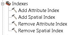
2) use the Add Spatial Index tool. In Arc Toolbox expand Data Management Tools > Indexes  and open the Add Spatial Index tool. Select your layer as the Input Features in the tool and click OK.

An advantage to using the ArcToolbox tool is it may be used to rebuild an existing spatial index. ArcCatalog may only be used to create an index if one does not already exist.

After creating a spatial index, the Show MapTips option should be available for your layer.

ArcGIS Geoprocessing tools

Long-time users of ESRI products may remember the “Geoprocessing Wizard” tool that was available in ArcView 3.x and in ArcGIS 8. Though it was handy to have these common analysis tools in one location, this wizard was removed in ArcGIS 9 and the associated tools were ‘relocated’ to other toolboxes.

The functions of the Geoprocessing Wizard included: MergeClipIntersectUnion, and Buffer

These tools may be found in the following toolboxes (both in ArcGIS 9 and 10):

Merge: Data Management Tools > General > Merge
*the Merge tool was called ‘Append’ in ArcGIS 9.0 and renamed in version 9.1 and later
Clip: Analysis Tools > Extract > Clip
Intersect: Analysis Tools > Overlay > Intersect
Union: Analysis Tools > Overlay > Union
Buffer: Analysis Tools > Proximity > Buffer (or Multiple Ring Buffer)