ArcGIS Pro crashing when editing symbology

This bug was introduced when Microsoft made some changes to their dotNet libraries back in November. The fix? Install a patch to the latest version of ArcGIS Pro 2.8 or 2.9. Links are below. You will need to be logged in to Google with your Michigan Tech credentials to download the patches.

Patch for ArcGIS Pro 2.8

Patch for ArcGIS Pro 2.9

ArcGIS Pro version 3.0 and up is not affected by this bug as it uses a newer version of dotNet…

Watershed modeling (Flow Direction) in ArcGIS Pro

You may run into issues when trying to run the Flow Direction tool in recent versions of ArcGIS Pro. This usually is evident as the tool taking an unusually long (infinite) amount of time to run to completion. A workaround that we have identified is as follows:

Make your selections as you normally would in the tool under the Parameters tab.

Next, switch to the Environments tab in the Flow Direction tool. Enter 0 under the Parallel Processing Factor option.

Click Run. The tool should run in a normal amount of time.

Add Coastal Vignettes to your map

Coastal Vignettes are graphic representations of where land and water meet. Vignettes are symbolized so the land appears to gradually fade into the water, representing shallow areas near shore transitioning into deepening water.

Trees


image source: esri

Not wishing to ‘reinvent the wheel’, here are some postings about the creation of coastal vignettes in ArcGIS from the fine cartographers at Esri:

1) Symbolizing Shorelines   2) Ask a cartographer: coastal vignettes  3) FAQ: What are coastal vignettes and how can I create them? 4) Vector and Raster Methods for Creating Coastal Vignettes (ESRI white paper linked from #3).

These were written for older versions of ArcGIS but are still current…


Keeping ArcGIS up to date

All software is released with some bugs. Software vendors will periodically provide updates, patches, or service packs to fix issues identified with their software, and Esri is no exception. Discovering what fixes are available, as well as finding the correct updaters on their web site, can be a bit tricky. Below you will find some tips to help a) navigate their support site, and b) decide if you need to install the updates you find.

First, visit support.esri.com. This page has links to esri’s knowledge base and support forums, as well as their downloads. Look for “Patches and Service Packs” at the top of the Downloads list.

The list that appears may be somewhat is overwhelming, as it includes more than 80 products–some legacy, and some that have been renamed over time. The trick is to find the correct product in the list and drill down from there. With a product list whose names have transmogrified in recent years, this is no mean feat.

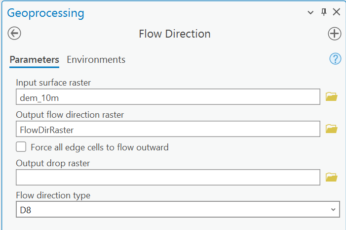
The esri software that most of us use is ArcGIS, named in the resulting list as as ArcGIS for Desktop. (Please note that if you have any extensions installed, they may be listed separately. You should occasionally check for updates to extensions you use often).

Once in the list of Patches and Service Packs for ArcGIS for Desktop, a browse filter is available on the right side of the page. 

In the browse filter you may deselect the versions of ArcGIS that you don’t use. Clicking the Go button will shorten the list of available updates to include only those for your installed version. The installers will be presented from newest to oldest. It’s still a long list, but is less cluttered and pertinent to your ‘flavor’ of ArcGIS.

Some tips for parsing this list:

• reading the summary for the update will help you decide if you should install it (these are provided on the list page). For example, if you never work with parcel data or imagery in format X, you probably don’t need to download and install patches to fix issues with those data types.

• If you identify patches you think you need to download and install, read the description page for more information. The top of each description page will contain the summary shown in the list (described above) plus hyperlinks to more extensive information, including a detailed description of the patch, what it fixes, who should install it, what it installs, where to download the patch, and how to determine what updates you have already installed.

• you probably should install any service packs or ‘quality improvement’ updates. The web page that describes the release will contain a link to ‘issues addressed’ by the software patch. SP1 for ArcGIS 10.1 purportedly fixed over 500 bugs, and the recent QIP release for 10.1 lists over 250 fixes. Wow.

• a service pack will contain all prior patches and updates, so anything older than the service pack doesn’t need to be installed first.

If you have identified updates you need, are a Michigan Tech employee or student, and don’t have administrative access on your office computer, send an email to it-help to request that the patch be installed. Please be specific, with a link to the installer, as well as your computer hostname.

If you have any questions, please contact me directly.

ESRI releases new toolbox

ESRI has released an update to the Spatial Analyst Supplemental Toolbox, bringing the version to 1.3. It adds new tools for zonal statistics and tabulate areas functions, and new options for watershed analysis (he determination of maximum upstream elevation).

An overview and details are available at the ArcGIS Resources blog. A direct download link to the toolbox is http://esriurl.com/SpatialAnalystSupplementalTools  and a complete discussion of the tools in the toolbox is at Introducing the Spatial Analyst Supplemental tools

Please note that ArcGIS 10.1 SP1 or later is recommended.


Student version of ArcGIS (10.1 and 10.2)

ArcGIS 10.2 was recently released. This has changed the method for activating a student edition of ArcGIS 10.1

http://www.esri.com/apps/Products/ArcGIS/ArcEdEval10/index.cfm?event=evaluate.index

Use the link above to pre-register your activation code for ArcGIS 10.1. If you use the link http://www.esri.com/StudentEdition you will see an error (error code 7174) during the activation process.

I should have codes valid for ArcGIS 10.2 in the very near future. Look for further updates here if you are interested.

ArcGIS ModelBuilder tutorial

I have written a short ModelBuilder tutorial that shown how to use an iterator to automate a repetitive process – converting a number of polygon feature classes to rasters in a geodatabase.

If you are interested in learning more about what can be done with the ModelBuilder, explore the ArcGIS Help files (search for ModelBuilder) and work through the two tutorials, or request a code to take the ModelBuilder course from the Virtual Campus.