New base maps added to ArcGIS Online

ArcGIS Online continues to be improved, with additional functionality and data added. With tools to import shapefiles, text data, gps files, or KML data, it eliminates the need for a local ArcGIS installation (in some cases).

See http://www.esri.com/news/arcwatch/1211/new-content-basemaps-and-tools-added-to-arcgis-online.html

or http://blogs.esri.com/esri/arcgis/2011/10/12/new-arcgis-online-basemaps/

or http://www.esri.com/news/arcnews/fall11articles/arcgis-online-whats-new.html for more information about ArcGIS Online.

Using MapTips in ArcGIS

It is often useful in a map to enable “MapTips” for layers in an ArcMap document. When map tips are on, hovering the cursor over a feature on the map will display the contents of a field from the attribute table in a pop-up window. This eliminates the user’s need to use the Identify tool on a layer.

To turn on map tips, open properties for the layer and choose the Display tab. In the Display Expression box, select the field you would like shown in the pop-up and check “Show map tips using the display expression“.

However, you may find this option unavailable (“grayed out”) when trying to enable map tips.

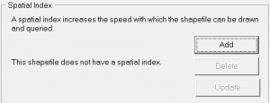
This is usually caused by the layer not having a spatial index available (see this post from ESRI for more information). The solution is to build a spatial index. This may be accomplished two ways:

1) in ArcCatalog, navigate to the layer, select it, and open Properties. Choose the Indexes tab and click Add under Spatial Index.  
2) use the Add Spatial Index tool. In Arc Toolbox expand Data Management Tools > Indexes  and open the Add Spatial Index tool. Select your layer as the Input Features in the tool and click OK.
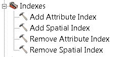
An advantage to using the ArcToolbox tool is it may be used to rebuild an existing spatial index. ArcCatalog may only be used to create an index if one does not already exist.

After creating a spatial index, the Show MapTips option should be available for your layer.

Add the Buffer Wizard to an ArcMap toolbar

Earlier version of ArcGIS had a ‘buffer wizard’ tool available. This functionality is now housed in the tools “Buffer” and “Multiple Ring Buffer” found in ArcToolbox > Analysis > Proximity. However, if you prefer the wizard interface, it is still possible to add the Buffer Wizard to a toolbar in ArcGIS. The instructions below are for ArcMap 10.x

  • Customize > Customize Mode…
  • Click the Commands (center) tab
  • Scroll down in the Categories list until you find Tools. Click once to select it.
  • Find the Buffer Wizard in the Commands: list on the right
  • Drag the Buffer Wizard icon to any existing toolbar (I suggest the “Tools” toolbar) and drop it wherever you like
  • Clicking the Buffer Wizard icon will launch the wizard…

You can customize any ArcMap toolbar in this fashion. See the ArcGIS help topic “adding a command to a toolbar or to the main menu” for more information.

DNRGPS released – replaces DNRGarmin

The Minnesota DNR released DNRGPS on February 15, 2012 and has already issued an update to fix some functionality problems. DNRGPS is the long-awaited replacement for DNRGarmin 5, and is designed to address incompatibilities between ArcGIS 10 and DNRG. It will also work with GPS units not manufactured by Garmin, Inc, prompting the name change.

DNRGPS is written as an Open Source application, and utilizes other open source software for portions of its core functionality (notably gpsbabel and GDAL). The developers are still working on updates to the program – be sure to read the known issues, release notes, and help file found on the application’s web page.

DNRGPS requires Windows XP or Windows 7, and works with ArcGIS 10 and Google Earth. Long-time users of DNRGarmin will want to do some testing before using DNRGPS on a daily basis. The move to open source underpinnings has changed how the software operates, notably how projections are handled. The ArcGIS toolbar is no more, but Geodatabase functionality has been added.

Stay tuned for more impressions and tutorial data.

A fix for ‘script errors’ when running tools in ArcToolbox

I recently was made aware of a fix for the long-present problem with ArcGIS on domain machines (i.e., users log in to lab or office machines using their ISO password) where a script error is generated every time a tool in ArcToolbox is opened. After dismissing three error dialog boxes, the tool will run ‘normally’. Not a fatal error, but annoying.

The problem stems from Internet Explorer, and can be fixed by replacing two files in \program files(X86)\ArcGIS10.0\ArcToolbox\Stylesheets

A description of the fix and the replacement files are available from http://support.esri.com/en/knowledgebase/techarticles/detail/38099

Administrator privileges are needed to implement the fix.

ArcGIS tips document

ESRI has created a nine page ArcGIS Desktop Tips and Shortcuts document. It lists keyboard and mouse shortcuts for many common operations, and identifies which work for versions 9 and 10 of ArcGIS (ArcMap and ArcCatalog). A shorter list is available in the ArcGIS 10 application help files. Tap F1 when ArcMap is running and search for keyboard shortcuts.

You can also use the Help files for ArcGIS 10 in the ArcGIS Resource Center. Search for keyboard shortcuts. Help for other versions of ArcMap (or other ESRI applications) can be found by going to the ArcGIS Resource Center and clicking Help. Expand the list for the application you are interested in (click the +) for help files from the older versions.

Tip: the help files from the Resource Center are the most up-to-date for all ESRI software. Sometimes updated documentation is not included with service packs and patches, but these files are kept current.